Bigfoot 73 Race Report
Posted by ekr on 14 Jul 2021
Last weekend I ran Bigfoot 73 miler up in Washington around Mt. St Helens. I didn't go into this season planning to race Bigfoot but then San Diego 100 was canceled thanks to COVID-19, so I had to find something else and Bigfoot looked interesting
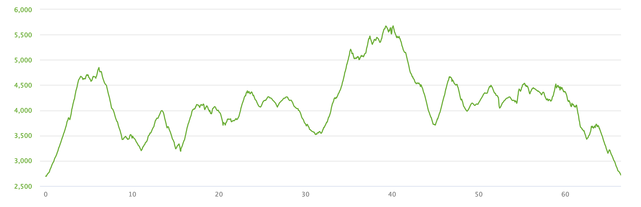
As advertised, this was hard, but overall it went quite well. The course was extremely technical with many steep climbs (see the altitude profile below) and several a few sections that requires some scrambling and the like, as well as two long boulder fields that you really had to pick your way through, one of which was in the dark. An extra challenge here is that because the course is so remote the aid stations are very far apart, with the longest stretch between aid stations of about 18 miles. It was not however, 73 miles but rather about 66.
Start to Blue Lake #
I had to get up about 2:30 to get to the race on time for the 5:30 start. The first 4 miles or so are a 2000 ft climb and consistent with my strategy I took it out pretty hard, power hiking pretty much the whole way but doing it at the top of the hiking range, using poles (Black Diamond Carbon Z) with the usual double pole technique. At this point I should mention that many ultras, especially more mountainous ones, involve quite a bit of hiking rather than running. Once things get steep, it's far more efficient to hike than it is to run and ultras are all about conserving energy.[1] I started out somewhat towards the front and passed a number of people on the climb. Once you get to the top there is an extended boulder field of about a mile, with the boulders being maybe 1-2m wide. I had some trouble with this section, partly because the poles don't really help that much in this setting but I had trouble getting them back into the Salomon quiver, which actually fell off (I ended up stuffing it in my pack eventually). I mostly just kept the poles in my hand and made my way through, but lost some time.
After the boulders, there's an extended descent down to Blue Lake, over quite runnable single track. I caught up to a number of people on that section and mostly didn't see them again. I wasn't feeling that great during this section and it seemed very long. I also tripped quite a few times but didn't go down, which is usually a sign of fatigue for me, which is unusual this early in an event. I was surprised that came in at 2:37, which was ahead of schedule. This was billed as a 12 mile stretch but my GPS said 11 (the aid station volunteer billed it as 13) and others reported the same.
You'll notice at this point that this isn't that fast: about 14 minutes/mile. Partly this is because I'm not incredibly fast, but in general mountain ultra-trail races are slow. For instance, Jim Walmsley's phenomenal 14:09 Western States record is somewhere over 8:00/mile. This is due to the length of the course as well as how much slower people run when climbing.
Blue Lake to Windy Ridge #
The next stretch to Windy Ridge was long and exposed, but without as many really long climbs. Mostly, it was just a long section of modestly rolling terrain crossing stream beds, so you would have to keep going down into the stream bed and then climb back out. I ran the flats and descents where I could (a lot of them were quite rocky) and then hiked the climbs. I used the poles almost the whole time here, which mostly worked well except for one quite difficult section which involved a rope descent followed by a rope climb out of the same gully, which was hard to do with poles in hand.
Because this section is so long, it's not really practical to carry enough fluid: at 15 minutes/mile 15 miles is almost 4 hours and in the heat you'd like to do 500-1000ml/hr. I was carrying 2l but that's obviously not enough -- and you don't want to carry more because water is heavy -- so you need to drink water from streams and the like. However, these sources are sometimes contaminated with giardia or the like, so you want to treat the water. I use a Salomon XA filter that is just a cap that fits on your water bottle, so you can just dip the bottle into the stream and drink directly from it. Definitely was doing some of this on this section.
Finally, there's a long out and back to Windy Ridge on a dirt road, with about a mile climb and then a mile descent. Was able to really push here.
Windy Ride to Norway Pass #
Leaving Windy Ridge, I noticed I was getting some pain in my left foot. I thought it might be a blister[2] but when I took my sock off it was more like a wrinkle in the foot that had gotten swollen because of moisture, so I put some lube on the hot spot and kept moving.
The Windy Ridge to Norway Pass section is the longest (billed at 20
miles but actually 18) but it's also middle of the day and hyper
exposed. The first tranche of this is mostly across the same kind of
lowland river terrain, so there was a fair amount of bushwacking,
followed by a long climb in to the highlands and then a lot of
traverse across snow fields and the like. Did a lot of this with
Jennifer Schweiger, the eventual female winner second-place finisher before she dropped
me. It was getting quite hot by this point and I was starting to run
out of water and I got a bit fooled by how much fluid there was in the
lowlands, but by the time we got to the highlands there were
snow fields but not much water and I was down to like .75l with 7+
miles to go. I initially stuffed snow into my filter but before it
could melt we found some actual runoff, so that was easier.
At this point I was starting to feel kind of nauseated (probably due to not drinking enough) and it was a struggle to get in fluid and calories. In particular, because I was mostly drinking water I wasn't getting that much calories and the PowerGel I had brought started to taste kind of gross (surprisingly Spring energy was better even though a usually not a fan). At this point Jennifer starting to pull away, somewhat on the climbs but mostly on the snow fields where I'm not that good and also on the flats where running was starting to feel pretty difficult and eventually she gapped me and I didn't see her until the end. There's a long descent into Norway that's mostly single track and that felt comfortable, though I was working a bit to keep up with someone else I ran into.[3]
Norway Pass to Windy Ridge #
You just turn around and climb out of Norway. I felt good here. The backtracking part isn't that steep but then when it diverges from the trail in it's some real bushwhacking, which was pretty hard. Next it opens out out onto the highway and you have to do a long 2-3 mile on the road, which I was able to do very quickly. Then there's a traverse and a dirt and stairs descent into Windy Ridge.
First Coke here.
Windy Ridge to Finish #
I had a spare pair of socks at Windy Ridge so I changed them and lubed up my feet and headed out back out the dirt road for the last 13.5 miles. This last segment comes in five main pieces: (1) a steep climb (2) a long up/down section of stream gullies and big rocks (3) some nice dirt single track (4) about a mile long boulder field (5) a dirt road descent. The river gully section seemed very technical though this may have just been in the dark; you would go down this rock and scree slope, cross the bed (sometimes dry, sometimes not) and then come back up.
First caffeine capsule around here.
At this point it was starting to get dark, so I had to do this on headlamp Petzl Actik Core. I'd been doing pretty well in terms of stability but I stumbled a bunch of times in the stream gullies. I had two notable falls, the first where I stepped off the path with one foot and almost slid down a long sandy slope. I ended up with just my arms and head on the path and had to grab a rock and pull myself up. The second I tripped on a rock and nearly landed face first. I got some bruises from that but was able to walk it off.
Second caffeine capsule around here.
The dirt section after that was OK, and I thought I was getting close to the end but then ran into the second boulder field. This part was especially hard, objectively probably no worse than the first one, but in the dark it was hard to wayfind and to stabilize. Finally, it opened up onto the dirt road back to the start.
Battery change here: note that it's hard to change the battery, especially to disposables without light. Fortunately someone had one, though I could have used my phone.
At this point I was with two other guys, Tim and Saul. Saul took off fast and I followed a bit behind. I was watching my GPS and it looked like I was off course and so I backtracked back to the intersection, where Tim and I looked at the GPS track which showed another trail, but the markings clearly showed the trail we were on, so I turned around and took the trail I was originally on. This probably cost about 5 minutes. From there it was easy downhill till the end. I was feeling good at this point, and was limited by the footing, and wouldn't have had trouble going longer, or harder with smoother trail.
Retrospective #
Generally, I think I paced this pretty well. I do think I had some spare aerobic capacity and might have been able to run a bit more of the runnable trail bits towards the end, but in many cases things were just unrunnable and even hard to hike, so I would actually probably have benefited as much training wise from really steep hiking.
I think my heat training was also a success. I had spent a lot of time running in the heat and sitting in my car with the heat on in order to adapt. It was warm but I never felt that overheated, though of course I was thirsty.
I felt kind of bad at the beginning and was kind of tempted to pack it in at Windy 1 (where you could drop down to 40), but that eventually faded. Not quite sure the mechanism of that. I think honestly I might have just been feeling the weight of a really long day once I realized that there were going to be a lot of physically demanding pieces as opposed to just running/hiking.
A few things could have gone better here. Probably the biggest is nutrition. Because of the long segments here, I never had enough tailwind sports drink to go the whole way between aid stations -- and with the Salomon filter it's difficult to just filter directly into a bottle -- so I probably was only getting about 1/2 as many calories as I do in training, and I quickly lost my taste for gels and even M&Ms. I also probably wasn't drinking enough in general. I did try to aggressively drink at aid stations and I think that helped some. This would be easier at a more conventional race because you wouldn't run out of sports drink as much, but still I think I would do better with more of a mix of food and less of a reliance on gels and sweet stuff.
I need to figure out some better story for pole storage. I did want them most of the time, but it was enough of a hassle to stow them that I kept them in hand in places where it might have helped earlier. The Salomon quiver was kind of a fail but also bungee-ing them to the back doesn't work well for me because they're hard to get on and off.
I had balance/tripping problems in two sections: at the beginning where I tripped a lot but never went down and then at the end when I actually fell twice. I'm not sure about the beginning, it just felt like I wasn't warming up that well and that got better as the day went on. At the end of the day I had a lot of balance problems on the difficult terrain. Some of this is expected and I of course saw other people fall too, but there's room for improvement. In particular, I had more trouble on the boulder sections than others I think. Some of that may be down to poles in hand (see above) but some of it could benefit from balance work.
I wish I'd gotten on the bottom of my foot earlier. It never got so bad that I couldn't run but it kept threatening to and now there is a blister about 1x2cm. I had spare socks and should have swapped at Windy both times. With that said, my feet kept getting wet and dirty and at the end of the day it was fine. The Salomon Sense 4 Pros handled this all pretty well, though the laces do come out of the pocket if you're not careful.
Finally, it was a mistake to trust the GPS track over the course
markings at the end. If I hadn't backtracked, I think I would might have
been one place up. Serves me right for being obsessive and
completionist about the right course.
Results Summary #
| Time | 19:25 |
| Actual distance | 66.4 miles |
| Place |
Note: I am still waiting for the results, this
is from the tracker, so I might be one place back.
Updated: 2021-07-16 now that the results are up. To be honest, the situation is a little confusing, as these results do not agree with what I heard right after the race, with what appears in the tracker, or what was originally posted yesterday, in that there are several new names in the top 10, so I'm not quite sure what happened.
| Segment | Distance | Elevation | Time | Pace | GAP |
|---|---|---|---|---|---|
| Start to Blue Lake | 11.01 | +2631/-2113 | 2:37:46 | 14:20 | 12:14 |
| Blue Lake Aid | - | - | 8:01 | - | - |
| Blue Lake to Windy Ridge | 15.71 | +3189/-2326 | 4:16:22 | 16:19 | 14:10 |
| Windy Ridge | - | 10:36 | - | - | |
| Windy Ridge to Norway Pass | 18.06 | +3356/-3701 | 5:13:12 | 17:20 | 15:09 |
| Norway Pass | - | - | 18:07 | - | - |
| Norway Pass to Windy Ridge | 7.49 | +1598/-1253 | 2:03:20 | 16:28 | 13:57 |
| Windy Ridge | - | - | 8:38 | - | - |
| Windy Ridge to Finish | 19:39 | +1916/-3261 | 4:32:14 | 19:33 | 17:50 |
| Overall | 66.43 | +12674/-12651 | 19:24:59 | 17:32 | 15:27 |
As an example, a few weeks ago I did much of the Bright Angel trail in the Grand Canyon twice a few days apart, once hiking and one running. I was only about two minutes/mile slower hiking and it was much easier. ↩︎
It's very important to address incipient blisters early, because once a blister gets big it can make it very hard to move fast. Irunfar has a good guide to blister treatment. ↩︎
This dynamic is just how ultras go; you meet up with someone who is about your pace and you go together for a while. It's good to have someone to talk to and it helps keep you moving. People will sometimes adjust their pace a bit to let someone else keep up, but at the end of the day it's a race, so if you're too different, then you end up splitting up. ↩︎