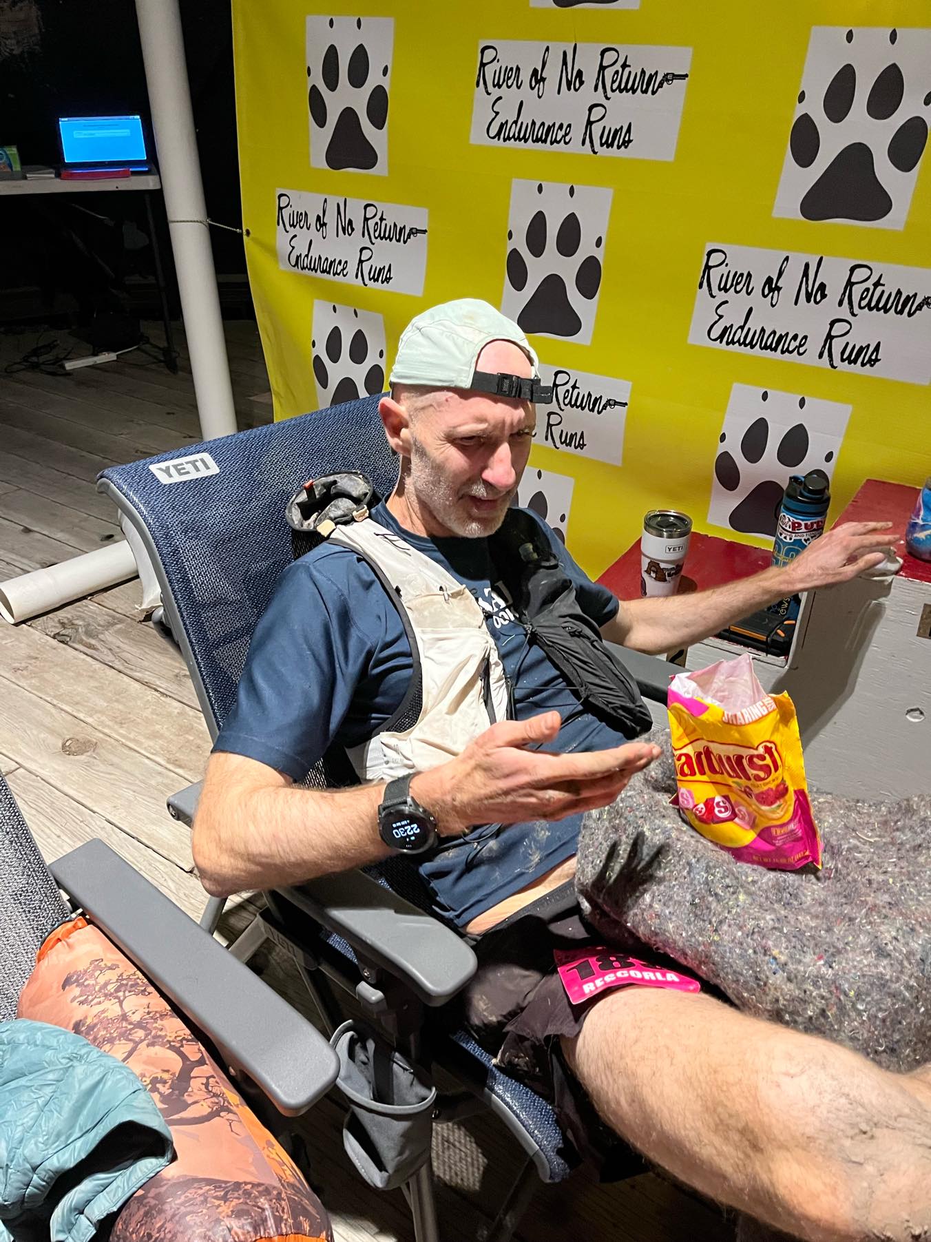
River of No Return 108K Race Report (2024)
Posted by ekr on 05 Aug 2024
My "A" races for 2024 were Sean O'Brien 100K at the end of January and Tushars 100K at the end of July. 6 months is a long training block and so I decided to break it up with something in between. I've been leaning towards mountainous races with a lot of vert lately (SOB notwithstanding) and after doing a bunch of searching on UltraSignup I decided on the River of No Return 108K (RONR)[1] Challis Idaho. This turned out to be a good call because I ended up bailing on Tushars after the race was seriously impacted by a giant fire.
Here's a long-delayed race report for RONR.
Badwater Crewing #
Badwater logistics are nuts. Unlike most ultras which have aid stations, Badwater is just an undifferentiated stretch of road and your crew has to follow along in a van and can (mostly) crew you wherever you want. They just pull over to the side of the road, feed you, etc., and you keep going. It's also unbelievably hot and the crew is likely to be pulling at least one all nighter themselves, if not two.
RONR (pronounced row-nurr) is nominally 68 miles and ~17000 ft of gain, with pretty much the whole race above 5000ft, so it seemed like a good warm-up for Tushars (100K and 17000ft mostly above 9000 ft). The original plan was to do RONR as a "B" race without really going to the well and then try to really focus on Tushars, but my friend Lisa asked me to crew her at Badwater 135, which is the week before Tushars and the more I looked at the schedule the more I realized that it was going to be tough to really land the taper for Tushars, so we promoted RONR to at least an "A-", meaning that we would set up the training block for Tushars but I'd still taper for RONR and wouldn't hold back on the day.
The training block leading up to RONR went really well and then in the last mile of my last longish run—a week out so already into my taper—I caught a toe and landed really hard on my right hand. The next day the wrist was really swollen and I was worried I'd actually broken something, which would have obviously interfered with racing—especially because you want to use poles on a race like this and so you need to be able to push with your hand—but an x-ray didn't turn up anything, so it was just ice, advil, and crossed fingers.
Course Info #
Screenshots from Runalyze
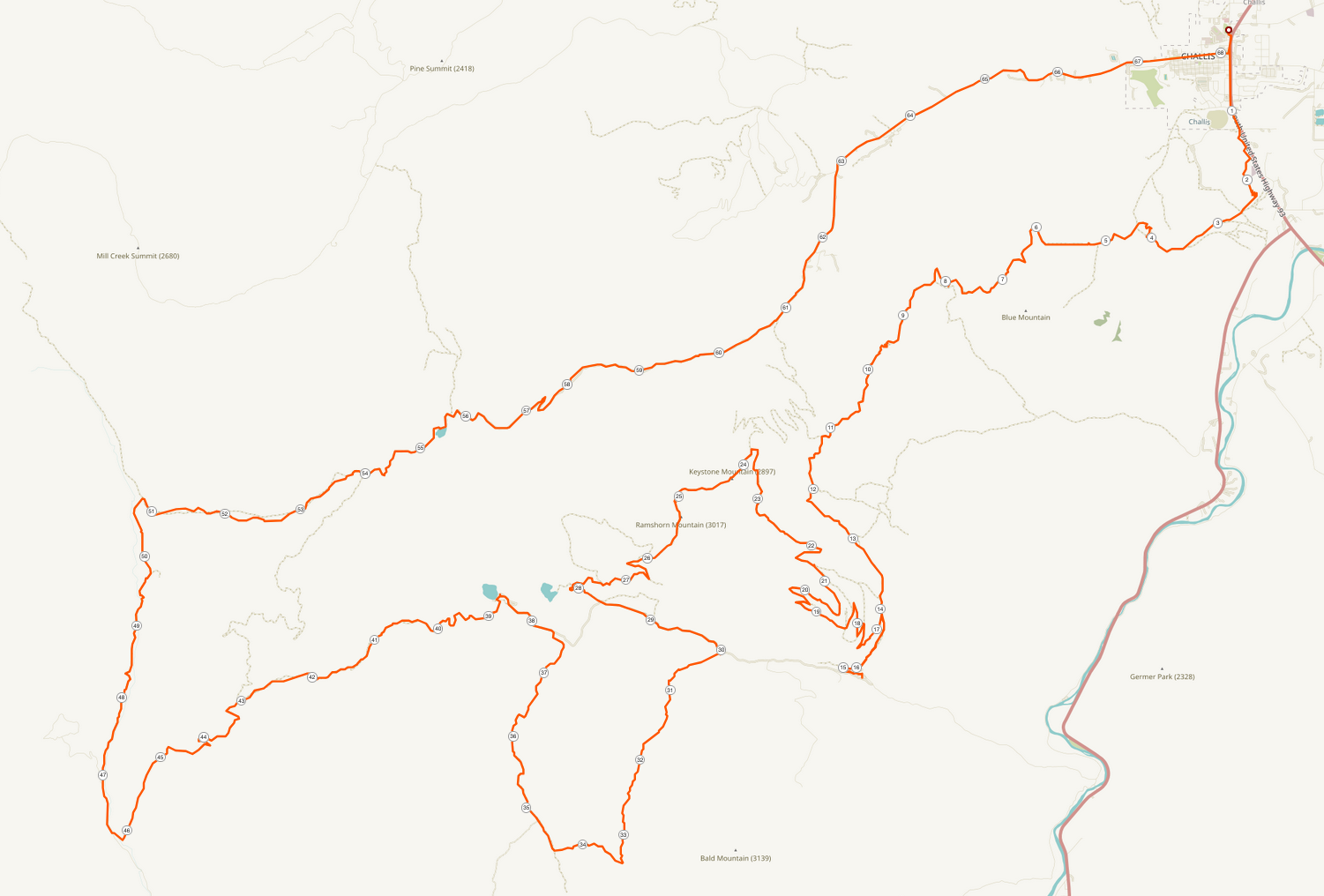
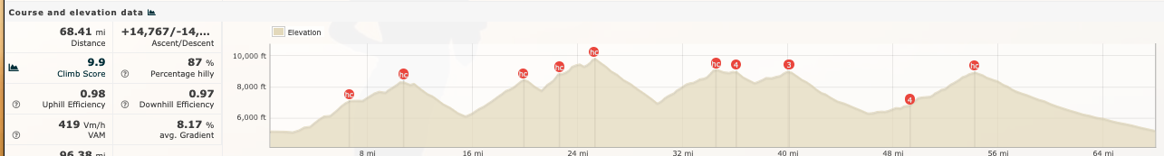
Above is a map of the course along with a profile. There was quite a bit of uncertainty about the actual amount of vert, with the Web site showing a bunch of different values (17000 on the site itself, 15314 in CalTopo, 16425 in ultraPacer with the same GPX, etc). Computing the amount of vert from a GPX is kind of a mess. As the Runalyze guys say:
The calculation of elevation data is very difficult - there is not one single solution. Bad gps data can be corrected via srtm-data but these are only available in a 90x90m grid and not always perfectly accurate. In addition, every platform uses another algorithm to determine the elevation value (for up-/downwards). We give you therefore the possibility to choose algorithm and threshold such that the values fit your experience.
I figured it would be around 15000 ft or so and at the end of the day Runalyze shows 14767 and Garmin 15439, so that seems to have been about right. As you can see, it consists of four big climbs, up to around 10kft and all above 5kft, with a really long final descent into town at the end. The last descent is kind of a mixed blessing, with the last 5 miles being on actual asphalt, so you really don't have much of excuse not to run, but you know it's not gonna be fun.
Looking at past year's times I was struck by how slow they were: the course record was set in 2021 by Jimmy Elam at 11:03, which is really slow for a 100K (the SOB record is 8:24). Sometimes a slow course record like this means a soft field, but not in this case: Jimmy Elam was 14th at UTMB in 2022, doing 22:36 the same year Kilian Jornet did 19:39 (and I did 37:49) and so I knew it was going to be a long day, estimating between 16 and 18 hrs. I used ultraPacer to give me a pace sheet for 16:30, which seemed on the optimistic side.
The weather on the day was actually really good, but it was a close thing: two weeks out there was a lot of snow on the course and then the next 12 days or so were really hot, so the course was actually almost snow free. When we drove in on Thursday it was unbelievably hot but it cooled down on Friday and then Saturday was nice and cool.
Travel #
Challis is not easy to get to. I had originally planned to fly to Salt Lake and then drive (5+ hrs) but then decided instead to fly to Sun Valley. Neither of these is ideal. There is no direct flight from SFO to SUN on Friday so you have to fly in on Thursday. Normally this isn't a big deal as you just chill out at the location, but if I'm racing at altitude I prefer to get in the night before to minimize the crappy acute altitude adaptation phase that happens after 24 hrs or so, and you obviously can't do that. On the other hand, if you fly into SLC, then you can come in on Friday, but you get in super late, which also isn't great.
I stayed at one of the recommended hotels (the Challis Village Inn), which turns out to have been a great choice as it's about a half mile away from the race start/finish. This meant we could walk over in the morning without having to build in a lot of extra time to deal with glitches around race day parking.
Challis is a pretty typical small town, but just a heads-up if you're thinking about doing RONR that the restaurant situation is pretty limited: there are only a few places and most only have like one vegetarian option (e.g., grilled cheese). Moreover, there's nothing really open after 10 PM, so think about that when you plan for your post-race meal. There is, however, a perfectly reasonable grocery store, so it's not like you can't get food and cook for yourself (my hotel room had a stove and a microwave).
Overall Logistics #
My plan was to use the same food schedule as I had used for SOB, namely Maurten and more Maurten. RONR serves Tailwind (which I like OK) and Gu (which I don't love), so I decided to mostly just carry stuff and use drop bags. There were only 3 drop bag stations, so this meant carrying a bit more food than I usually want, but it never got too heavy.
My feed schedule is roughly:
- 1 500 ml bottle of Maurten 160 drink every hour, with 250ml each 30 min
- Some mix of Maurten solid and Maurten gel aiming for ~100-200 cal/hr.
I use a 30 minute timer to manage all this, so I have to do something every 30 minutes. I started with Maurten solid and then moved onto a mix of regular gel and the caffeinated gels.[2]
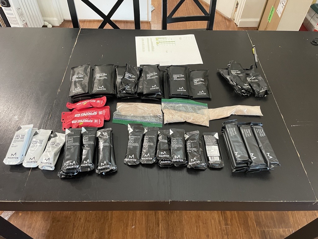
As before, I bagged up what I need for each aid station in a ziploc, as well as a sort "spare food" bag just in case.
RONR is a much more rugged race than SOB and due to all the snowmelt I knew there would be a lot of water crossings, so I also had spare socks in every drop bag as well as spare shoes in two of them in case I wanted to change. In the event I only changed socks once and kept the same shoes (Salomon S/LAB Genesis the whole time.
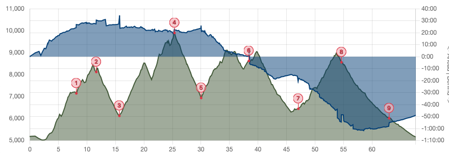
Start to Birch Creek [7.66 mi, +2329/-358 ft, 1:33:33] #
This first stretch is about 3 miles of rolling terrain followed by a long climb (the AS is about 2/3 of the way up). That first three miles is quite runnable and I was just trying to keep my pace contained, as it's easy to get carried away at the start, especially after watching the top pros just take off from the gun. This was made a bit easier by the definitely feeling that I wasn't at my fastest at 5000 ft.
I'd decided to start without a headlamp because sunrise was shortly after the start, so I had to be a bit careful, but you could mostly follow other people's headlamps in the twilight until the sun finally came up. I made it through this section OK and then managed to trip and land on my right hand (again!), but not badly enough to do more than make it more sore. This was the first of two falls on course and the only one that was more painful than embarrassing.
The climbing started soon enough and I was able to switch to hiking and poles. The trail itself was somewhere between double track and fire road, so it's basically just a matter of putting your head down and focusing on moving forward without having to worry too much about your feet.
This turned out to be my strongest section of the race, I think due to a combination of several factors:
- Low temperatures
- Being fresh and so comfortable pushing
- Not having had a chance to fall behind on nutrition.
- Comparatively low altitude (Birch Creek is at 7000 feet).
By the time I hit the AS I was almost 24 minutes ahead of pace for my already optimistic 16:30 target, and I was thinking I was going to have a pretty good day. The next AS (Keystone) wasn't far ahead, so I burned through the AS really quickly (~30s).
Keystone [3.56 mi, +1444/-463 ft, 55:45] #
It's mostly uphill from Birch Creek to Keystone and so just more hiking. I don't remember much of this, except that it went by fairly fast. I was still moving well so I continued to be well ahead of schedule. This stretch through Bayhorse was the furthest ahead of pace I ever was, almost 30 minutes; if you multiply that 6 (I was 11 miles into the race) we'd be looking at almost 3 hrs ahead, but obviously that wasn't going to happen. Another quick AS stop and then the long descent to Bayhorse Lake and the first drop bag.
Bayhorse [4.26 mi, +157/-2136 ft, 56:59] #
As you can see, this is a huge descent, which I mostly cruised. I ran this section with Kat Schuller, a runner with Rabbit Elite, someone about my pace to chat with and just get through the miles. Generally, in a race of this size I'll be somewhere near the female podium (I was behind the first woman at Sean O'Brien this year, though I would have been 8th at RONR), so if I'm with the elite women I generally figure I'm pacing about right. Kat's descending skills were a bit better than mine, so she'd drop me a bit on the trickier sections but I was able to just push a little bit and catch up once it got smooth.
We came into Bayhorse Lake together and arranged to meet up on the way out for the next big climb once we'd grabbed our drop bags, etc. In the event, though, I needed to hit the bathroom and by the time I came out and had my bottles filled, etc. I couldn't find Kat and wasn't sure if she had left already or was still at the AS (it turned out that she had decided she was in a race and had just taken off, but I caught up to her later) I waited around for a minute or two and couldn't find her, so headed out on my own. All in all, this was a really long AS stop; I had budgeted for 6 minutes but it was almost 10. On the other hand, I was still almost 30 minutes ahead.
Ramshorn [9.67 mi, +5000ft/-1250 ft, 2:58:32] #
This next leg is a 5000+ climb, made more interesting by the fact that it's also the first leg of the 32K, which started shortly after I left Bayhorse. This meant initially I had the really fast people passing me, but eventually things kind of stabilized as I caught up to people who had gone out too hard.
The Ramshorn aid station is almost 10 miles out and supposedly just a water drop, so I had planned to carry 2l of water, but right as I was about to leave Bayhorse I was told they had a water drop part way up so I scaled back to 1.5. I don't remember this stretch that clearly, so TBH I don't recall if Ramshorn was real aid or not. I do, however, recall starting to drag as I got up above 8000 ft, and as Ramshorn is the high point of the course at ~10000ft, that meant a long time working to breathe. Even so, I didn't lose too much time on this section, hitting the top at about 22 minutes ahead of schedule.
Towards to top of this climb I caught up to Lara Mccabee, an Idaho local and former track athlete. Again, it was good to have someone to run with so we stuck together for quite a while.
Juliette [4.58 mi, +64/-3024 ft, 51:31] #
As they say, it's all downhill from here, and the section from Ramshorn to Juliette is quite runnable double track and fire road, so it was mostly a matter of just cruising through it while remembering that we still had a lot of climbing to go. Not too much to say about this section; I stayed about 20 minutes ahead of pace.
Bayhorse Lake [8.36 mi, +3081/-1395 ft, 2:13:39] #
At the pre-race meeting, we were told that the climb out of Juliette had a lot of creek crossings, and it didn't disappoint. In any case, this is where things started to go sideways, I think due to a combination of factors:
- Fatigue
- Difficult footing and creek crossings making it hard to find my rhythm
- The altitude starting to get to me (Juliette is already at ~7000ft)
I left the AS with Lara and felt like I was moving faster, but in reality was just kind of yoyoing, and eventually we mostly just settled in together.
Psychologically this was a really hard section because I wasn't feeling great and there was still a really big climb to go out of Buster Lake. Worse yet, this stretch actually has two summits, with the first one followed by a mile plus stretch of rolling terrain and then a mile long descent and then another climb. This is all kind of hard to see on the Garmin watch, so I incorrectly thought that part of the rolling section was the second summit (wishful thinking) and it was pretty demoralizing to realize there was another big climb to go.
By the time I got to the Bayhorse Lake AS (not to be confused with Bayhorse) I had given up basically all of the time I gained in the first half of the race and was right at the ultraPacer target for 16:30. Unsurprisingly, things didn't get much better from here.
I had a drop bag at Bayhorse Lake and after all those creek crossings I decided it was time to change my socks, so I spent quite a while here wiping down my feet, swapping out all my nutrition, and watching the AS people try to get the Maurten in my bottles to dissolve (more on this later). While I was messing around, Lara picked up her pacer and left, but I figured it was more important to have my stuff in good order than to have company, and I knew I had my own pacer at the next AS.
Squaw Creek [7.57 mi, +847/-3023 ft, 1:43:14] #
There's some climbing out of Bayhorse, followed by a really long downhill. The downhill starts fairly technical with a bunch of rocks and talus and then turns into easy fire road. By this time I had caught up with Lara and her pacer, who had done RONR before and advised me that it wasn't worth trying to run the technical bit, because you wouldn't go that much faster and were just courting a fall. This was welcome news as I was feeling pretty tired.
Soon enough we hit the easier fire road section and from here it was just a long cruise down to the AS. You can actually see the transition quite clearly on the pace chart around mile 43 as I go from losing time to slightly making it up. The reason for this isn't that I was somehow a lot worse on the technical bits but that ultraPacer doesn't really know what kind of footing there is (you can tell it but I didn't) but instead is modeled on grade, so it overestimated pace on the technical sections and underestimated pace the easy sections. Somewhere in here I caught up and passed Kat, who had had a good middle section but was now dragging badly and eventually DNFed.
This section felt pretty long but was manageable, in part because I knew I would have company for the rest of the race once I hit Squaw Creek. At this point I was 20 minutes behind target.
Buster Lake [7.57 mi, +2854/-738 ft, 2:04:05] #
Squaw Creek isn't an official drop bag, but as my pacer Kate was there (she had been working the AS), she had brought food resupply, and I took a bit longer at the AS then I really wanted to. In the meantime, Lara and her pacer took off and I never saw them again (she eventually finished almost 30 minutes ahead of me).
The leg from Squaw Creek to Buster Lake is the last big climb and this was the hardest part of the race for me. Almost immediately I started to feel really tired and out of breath, and it just got worse as I gained altitude. Moreover, I was starting to feel really nauseated and dizzy. In the first few miles I actually had to stop a few times and just rest for 30 seconds or so. We were sort of going back and forth with a few other guys and after I'd passed them, I said I wanted to rest and Kate really saved me by asking "do you really need to or can you just slow down a bit?" That was the right question and the answer was of course "keep going, just slowly".
This section also had a lot of water crossings, though not as many as the previous sections, and some of it was really muddy. Partway through I just slipped and landed more or less face down in the mud. Nothing was injured but I got super dirty and just had to finish the race that way.
It was really a relief to hit Buster Lake, as it meant the end of the climbing and now I just had to survive the giant downhill. My last drop bag was here, so I swapped out my food again, with the intention that to eat gels from here on in, grabbed my headlamp, and ditched my poles (not going to need them on the downhill) and headed out. My stomach was still feeling pretty bad, so I grabbed some quesadillas in the hope they would settle things down—they go really well with dirt—and decided to hike a bit while I got them down.
At this point, I was 48 minutes behind target, but with 13 miles of downhill ahead of me.
Custer Motorway [8.35 mi, +290/-2841ft, 1:34:59] #
Like the descent out of Bayhorse Lake, this stretch starts out as somewhat technical rocky trail and then turns into fire road. As before, I opted to sort of hike the technical part and then run the fire road. I'd heard that this section was pretty easy, but the technical section seemed to go on forever—I was of course really tired, but even Kate said so—and even when I hit the fire road part, running didn't feel great and I found myself hiking some of the really not-steep uphill sections.
Finally, we got to the last AS at Custer Motorway. My stomach still didn't feel great at this point but they didn't have any quesadillas ready and I sure wasn't waiting, so spent almost no time here.
Finish [4.68 mi, +36/-878 ft, 50:09] #
From Custer to the finish is all paved road (it starts a little before the AS). I had been sort of going back and forth with a few other guys on the fire road section, but as soon as I hit the paved road I felt like I could really run again and Kate and I completely dropped them (eventually finishing almost 9 minutes ahead).
This section is entirely runnable and it's merely a matter of putting your head down and gutting it out. Kate and I had been talking all the way through here, but for the rest of the race I didn't want to talk but just needed to focus on keeping the pace up. This was the hardest I've ever pushed at the end of an ultra and it was super helpful just to have someone next to you keeping a steady pace when everything hurts. This section felt like it took forever and towards the end we were just counting down the tenths of miles to the finish, but we did the last 5 and change miles at 9:43, 9:42, 9:31, 9:05, 9:03, and 8:56 pace, going from over an hour behind target to just over 50 minutes behind.
Retrospective #
Overall, this feels like a solid result, though probably not as strong as Sean O'Brien. I went in not really knowing what to expect and so my pace targets were pretty handwavy. I would have been unhappy with 18 and quite happy with <17, so 17:18 seems reasonable.
My nutrition worked reasonably well, with two real things I'd like to deal with:
- As before, I felt like the bars at the start didn't go down that well.
- I was really having problems getting the Maurten drink to mix, even when I had volunteers shaking it for me. This is a known issue with Maurten, but it slows you down and it's also pretty gross when you get a bunch of wet powder in your mouth instead of gel.
The first item is easy: just switch to gels the whole way. I'm less sure what to do for the drink mix, as Maurten really just goes down a lot easier. I used Tailwind on a recent outing in the Sierras and after 6 hours or so I'd just had enough of how sweet it was. Maybe it's time to try Never Second.
I think the biggest limiting factor here was the altitude. It's always a challenge to go from sea level to 7000+ feet and while I was mostly OK at the start of the race, I could really feel myself dragging later whenever I got above 8000 or so feet. I suspect that this also contributed to my stomach issues, as nausea is a common altitude sickness symptom.
This probably isn't the best I could possibly have done with this training base but I don't think it was that far off. I lost a lot of time on the last climb—as you can see by Lara putting 30 minutes on me—and think it's possible I could have pushed it harder, but I doubt I could have gone that much faster. I think to really turn in a better performance I would have had to spend a few weeks at altitude so that the higher elevations didn't hit me so hard. I'm quite pleased with how much I managed to push the last hour or so. That's something I'll want to remember how to do in future races.
Overall #
17:18:39, 24th/(66 finishers, 92 starters), 17th/51 male, 2nd 50-59
That name sounds pretty ominous but turns out to refer to the 1800s when miners would carry supplies on boats down the Salmon river but not be able to get back up the river. In any case, I returned. ↩︎
As you can see, I also have some Spring energy gels. The flavor is a nice break from Maurten, but in light of the recent measurements of Spring's calorie counts coming in way lower than claimed, I don't want to rely on it. I had some floating around though, so figured I might bring it just in case I really lost the ability to tolerate Maurten. ↩︎