Highline Trail Adventure Run Report
Posted by ekr on 30 Nov 2021
TL;DR. Great views but slow going. Had to bail out at mile 38.
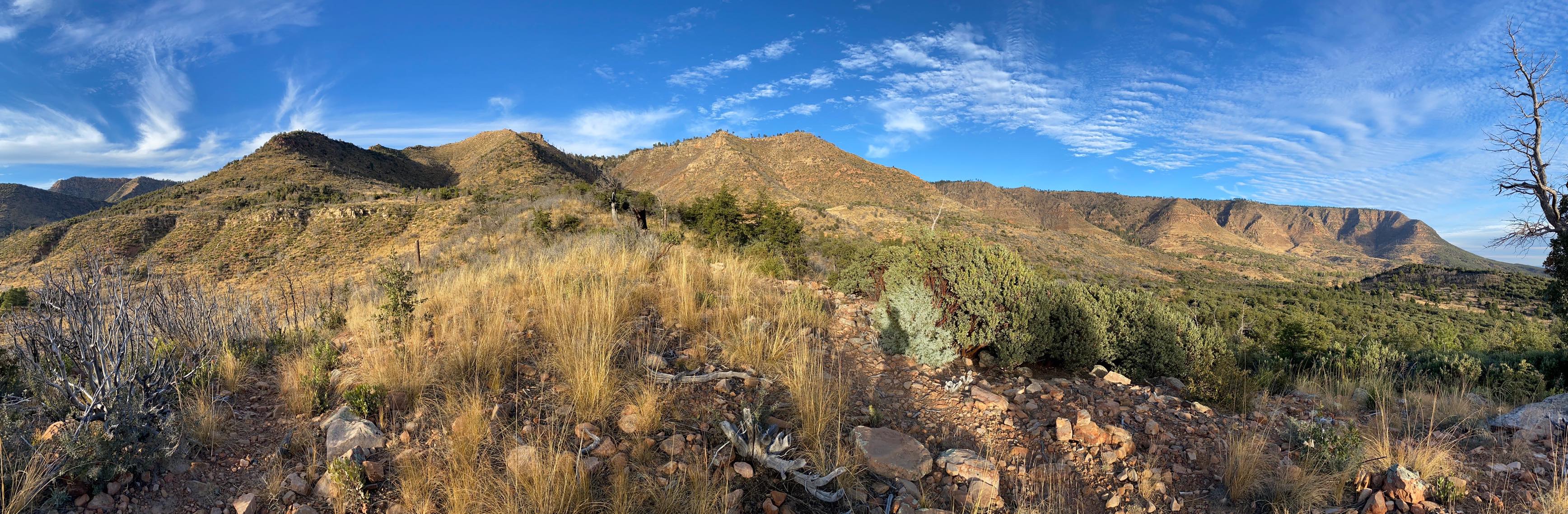
On Monday, November 22, For the last run of the season, my training partner Chris Wood and I decided to do the Arizona Highline Trail #31. We were already planning to do Zane Grey 100K which covers this trail and then some more, so this seemed like a good opportunity to check it out in non-race conditions.
In retrospect, this turns out not to have been as good an idea as it looked in advance. The basic statistics of the Highline Trail (50.6 miles, +7804/-6490) are actually quite manageable in a day (for reference I did Sean O'Brien 100K (62mi, +13130/-13130) in 12:53 (race report)). What really makes the difference here is that the trail itself is much more difficult, mostly very rocky and technical. I knew some of of this in advance because I'd done Zane Grey 50 mile back in 2019 (when it was an out-and-back from Rim Top Trailhead) and fell several times. What I didn't know was how difficult it would be to find the trail--and how easy it would be to get lost--without having the course pre-cleared and marked for me.
Logistics #
The Highline Trail runs from the Pine Trailhead (unsurprisingly, in Pine) in the West to 260 Trailhead in the East. There's no official way to shuttle between these two locations and I wasn't even sure we would have reliable mobile service to Lyft/Uber between them, so we opted to just rent two cars. We stayed at the Kohl's Ranch Lodge, which is about 10 miles away from 260 Trailhead, dropped one car off at 260 TH the night before and then drove the other one to Pine TH the morning of our run. The plan was to run to the 260 TH car, then drive back to Pine to pick up the other one.
Sunrise in this area is around 7:00 AM this time of year with sunset around 5:20, so there's no realistic way to avoid running in the dark. We planned to start around 5:30, figuring it would actually start to get light around 6:15-6:30 and then would have about 12 hours more of daylight. We prepped all our stuff the night before and got up at 3:40ish, figuring we'd leave about 4:20 and get to the trailhead a little before 5, use the bathroom, etc. and be on the trail before 5:30. This sort of worked: we were out a bit after 4 but then I realized I'd left all my bottles back in the refrigerator so had to head back to the hotel.
At the end of the day, we got to the trailhead around 5, but it was a lot colder than we had expected (~32 F), so we stalled for a while before we actually started and ended up spending about 10 minutes in the car with the heater on before we were willing to actually start. Then we immediately took the wrong trail and had to backtrack, so ended up starting at 5:58.
The Run #
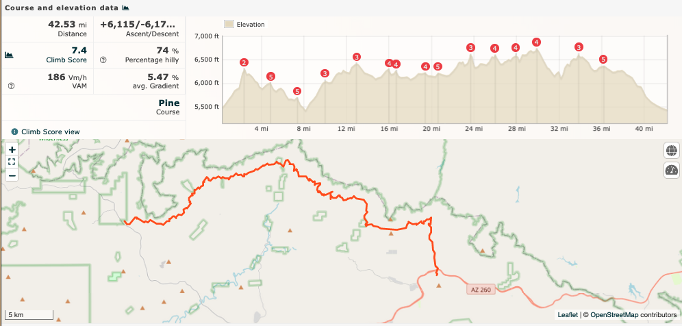
The trail is overall uphill, but there are really only three significant climbs: The first 2ish miles are a long climb of about 1000 ft (to 6300 ft) followed a long descent down to mile 8, a 5 mile climb (to 6400 ft) and then rolling uphill out to 30 miles and then one more 500ft descent/climb pair. There's also a long climb at the end, but as you'll see, we didn't make that far.
Start to Mile 22.5: Mostly smooth [+2786/-2782] #
We started out on headlamp and everything was fine for the first mile or so, at which point we realized we had gone offtrail. I had downloaded the TrailRunProject GPX file of the trail and we got relatively early notification that we were off. After some backtracking, we found the fork we had missed and proceeded upward only to make the same mistake about 1/3 of a mile later. In both cases we had to fight through some fairly thick brush to stay on trail. This whole first couple miles was kind of overgrown, so it was a bit hard to figure out.
In retrospect looking at the map, it appears that what happened is that the trail was rerouted a while back and the GPX we had was pre-reroute. You can see this on the map in Runalyze below:
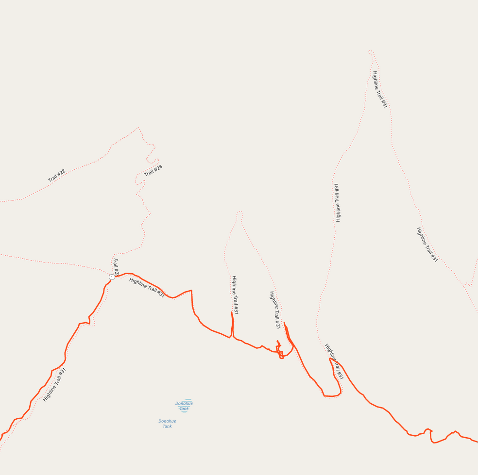
What seems to be going on here is that the GPX track takes the original straight through route but the newer route switchbacks more. It's in better shape which is why we kept taking it, and we should have just stayed on it, but instead we took the (mostly) unmaintained original route. This is a mistake we would make a lot later. No doubt it's much easier with ribbons at every turn.
Once we got through the first couple miles, though, things opened up and the trail was pretty clear. We also started to see a lot more trail markers (this section is both the Arizona Trail and the Highline Trail) and so were pretty confident we were on the right track. This lasted until about mile 22.5, when we ran right into a fence.
Time: 6:39
22.5-27: Things Start to Go Wrong [+764/-715] #
As I said, things were going fine until about mile 22.5, when we ran right into a barbed wire fence with a sign that said something like "Caution: Burn Area" (sorry, no picture). This wasn't entirely a surprise because I knew there had been a fire, but I also wasn't expecting a fence. There wasn't any obvious way through (though that's where the GPX track and the apparent trail wanted to go), so we spent a while backtracking and looking for alternate trails that would get us around but didn't find anything. Ultimately, we just concluded that this was actually a gate, unhooked the wire hanging the piece of fence with the sign, and went on through.
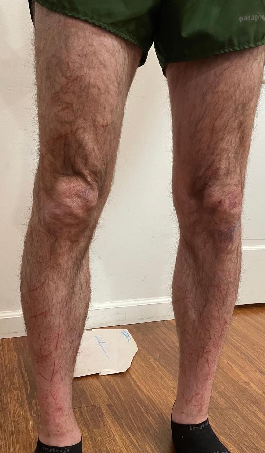
Unfortunately, this was just the first of a series of sections where we got lost. Much of the trail was badly overgrown with knee-length grass, so we were reduced to following what looked like the most trodden path through the grass and watching the GPS (with occasional assists from the map on our phones) to see if we were off track. Whenever that happened, we'd backtrack back to the point where we left the track and try to find out what had gone wrong. Usually we could find some faint track and we'd follow that instead. Obviously, this was super time consuming both in terms of how much it slowed us down to be constantly watching the trail and then actual backtracking. From here on in, there were also a lot of sharp plants and so we both started to accumulate various scratches (me more than Chris because he was wearing calf sleeves)
We ended up generally following a dry creek bed stream, but kept getting caught in one side trail or another. The confusing part is that these were obviously real trails and they were shown on the map. Eventually we realized that these were probably more reroutes and that if we had just followed them we would have been fine, but we only figured that out after we were mostly past this section. Somewhere in here we almost totally lost the trail. We were in the dry creek bed and could see that we were off course, but it seemed like it was actually at the top of a small wall? cliff? about 20 feet high. We ended up scrambling up it and were able to find another section of what looked like trail, so we picked that up.
At this point I was starting to get pretty worried. We were clearly making very slow time and it was going to get even harder to find the trail in the dark (this proved to be true later), and given how cold it had been in the morning I sure didn't want to be out all night. We had packed a few extra layers (arm warmers, gloves, rain jackets, and buffs for each of us, plus one extra long sleeve shirt, one pair of tights, and one pair of rain pants, plus a couple of emergency bivies) but none of that was going to make it fun to be running in the dark in freezing cold weather. Looking at the map, we found a small housing development around mile 32, so we figured if we could make it there we could somehow get a ride out, so we pushed forward, figuring in the worse case we could backtrack to the trailhead around mile 17.
Time: 9:00
27-32: Relatively Smooth Sailing [+709/-968] #
This next section was actually quite smooth. The trail was generally pretty easy to find (there were even markings!) and even runnable in some places. Relatively early on we crossed a dirt road which we probably could have bailed out on, but it would have require us to run for quite a while on that road to get to somewhere that we could have gotten a ride, so we decided to push on to the original point we had identified.
Of course, by the time we got there, it was also clear that we could go further. The next obvious bailout point was the Tonto Fish Hatchery, which was actually the turnaround for when I did ZG 50 back in 2019. The hatchery is just about 4 miles up the road from Kohl's Ranch, so if we got there we could make it there under our own power rather than having to get a ride from the middle of nowhere. After sitting down and having some caffeine we decided to push on.
Time: 11:15
32-38: To the Hatchery [+804/-732] #
The next few miles to the hatchery were actually pretty smooth. First we had to climb about 400 feet up and then it was generally downhill, all of which was quite comfortable once the caffeine kicked in. The trail actually intersects the road twice at the hatchery and we opted for the second intersection because it's more of a straight shot down to Kohl's Ranch.
In retrospect this may have been a mistake because by this point we were on headlamp and the trail suddenly got quite difficult to find. Instead of being a bunch of overgrown grass it was just bare rock with a bunch of cairns marking the way, so once again we were reduced to watching the GPX track and then kind of trying to find the trail from that and the cairns, not easy to do in the dark. Anyway, we eventually found the road (real road, not dirt road) and headed in.
Time: 13:15
38-42.5: On The Road [+39/-965] #
This last section was on asphalt and mostly downhill, so we took it pretty fast (~8:30 moving pace, which is tiring after 38 miles). There was obviously no real concern about finishing at this point, so we just slogged it out and tried to keep moving (with occasional breaks to obsessively check that we were on the right road) until we got to our cabin.
Time: 13:56
Now what? #
Of course, at this point we were stuck at Kohl's with one car at 260 TH and one at Pine TH. It's not exactly easy to get a Lyft or an Uber in the middle even from the hotel (validating our previous decisions), but we managed to convince one of the hotel staff to give us a ride to 260 TH and then picked up the car and headed to Pine, plus dinner, all of which got us back to the hotel at ~10:00 PM.
Nutrition #
Overall nutrition went pretty well, though we didn't eat anywhere near as much as I expected or brought.
Our hotel room at Kohl's had a full kitchen so we were able to make oatmeal in the morning; in the past I've just had Tailwind or an energy bar because I was worried about GI distress, but I tried steel cut oats at SOB 100K and that went well, so I went with oatmeal (regular this time) here and that was also OK. I also drank about 2/3 of a bottle of Tailwind on the way to the trailhead.
Overall consumption:
| Tailwind | 14 | 8 | 1600 |
| Powerbars | 8 | 3 | 600 |
| Gels | 5 | 3 | 400 |
| M&Ms | 1 bag | 0 | 0 |
| Total | - | - | 2400 |
We were worried about water ahead of time but it actually turned out to be fine and we were generally able to filter out of creeks, drinking it directly or filtering into bottles (Salomon XA Filter Cap FTW).
This probably isn't really enough calories but remember we were going quite slow, so you don't need as much as if you were running the whole way. I never bonked and didn't have any real GI distress at any point, so this seems like a success.
Retrospective #
Obviously, this was much harder than I had expected. I did ZG 50 in 12:01 a few years ago and after SOB 100K was hoping to finish ZG 100K 2022 in the high 13:00s, which would have put us around 11-12 for the shorter Highline trail (the distances are a bit fuzzy). In the event, we ran almost 14 for an abbreviated route. Most of that can be chalked up to the difficulty of the trail, both in terms of footing and in terms of routefinding. I expected the footing to be bad, but I didn't expect it to be so overgrown, which definitely slowed us down. However, I didn't expect to have so much trouble finding the route.
I remember the other part of the Highline Trail (remember, we bailed out right about where I turned around in 2019) as being much easier to find, but that may have just been that it was well marked and cleaned up before the race. A lot of this was our fault for trying to find the GPX track rather than looking at the map to see where the trail really was. That would have saved us some of our worst points of confusion, but we still would have had to constantly double check every time we hit a junction, so I'm not sure how much time it would have saved at the end of the day. It's definitely a lot easier when someone has put ribbons out.
As noted above, we brought too much food. I forgot to keep records for Tenaya though I know we brought way much then too. Now I have a real benchmark and I could probably have brought about 20% less and still been fine. No reason to over-carry.
The rest of our equipment choices seemed pretty reasonable. We decided not to bring poles and they would have mostly been in the way. I was right at the limit of my Salomon Advanced Skin Set 5 (in fact, it's now tearing out at a seam) but it did OK. I made a last minute decision to wear my Salomon Ultra 3s instead of my Sense 4 Pro because they're a bit more stable. I think that was a mistake because I like a slightly more precise shoe for this terrain--on the other hand, Chris did it in Ultra Glides so probably not a big deal; also my socks started to slide down and the collar of the Ultra 3s tends to rub a bit. I don't much like calf sleeves, but I sort of regret not wearing them in this case. That way my legs wouldn't have looked like this:
Fitness wise, everything was fine. I was never too wiped out and could easily have done the last 12 miles if I'd had to. The hardest part was actually the last 4 miles: pushing the pace on the road was just pretty unpleasant. Good mental practice, though.
I'm confident that we made the right decision to bail out at Tonto. I think we probably could have made to to 260 TH OK, but it would have been a long 12 miles (probably 3-4 hrs) in the dark and if anything had gone wrong, we could have been in real trouble. My general feeling is that the adventure part of adventure runs is best contained to the risk of being really miserable rather than the risk of life and limb.